Kurtekotten Motte
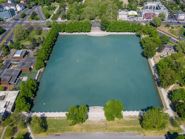
The remains of a medieval motte in Cologne-Flittard: a raised castle mound and a wide water-filled moat sit tucked between sports grounds and a dredging lake, protected as a natural monument.
The Kurtekotten Motte is a high-medieval motte-and-tower castle in the right-bank Cologne district of Flittard. Today the castle mound and its surrounding wide moat survive.
At a Glance
- Type
- High-medieval motte (tower-mound castle)
- Location
- Flittard, right bank of the Rhine; about 45 m west of the Mutzbach stream, roughly 170 m south of the Leverkusen city boundary
- Extent
- 90 m (north–south) × 70 m (west–east), total area 4,085 m² including the banks
- Castle mound
- near the centre, approx. 240 m², roughly square, rising about 3–4 m above the water level (45.5 m above sea level)
- Moat
- about 16 m wide to the north and west, approx. 21–24 m to the south and east
- State of preservation
- Mound and moat preserved; no archaeological investigation carried out
- Protection status
- Natural monument no. 909.01 under the North Rhine-Westphalia landscape protection act
Location and Appearance
The ruined motte lies about 45 metres west of the present course of the Mutzbach stream and roughly 170 metres south of the city boundary with Leverkusen. At its greatest extent the site measures 90 metres north to south and 70 metres west to east. Including the banks that slope down to the water, the total area is 4,085 m², while the castle mound itself covers about 240 m². The near-central, roughly square mound rises some 3 to 4 metres above the water level, which sits at 45.5 metres above sea level.
The moat is about 16 metres wide to the north and west and approximately 21 to 24 metres to the south and east. As late as the end of the 19th century it was directly linked to the Mutzbach by an inflow and outflow. No archaeological investigation of the site has yet been undertaken. Today the motte is bordered to the west by the grounds of RTHC Bayer Leverkusen on Knochenbergsweg, with tennis halls and courts, and to the east by a dredging lake.
History and the Kurtekotten Farmstead
No sources survive concerning the origin of the motte or its owners. The farmstead to the south-west probably arose only after the motte was abandoned; the farm existed into the 20th century. According to Bendel, in 1277 a Johann von Thurn gave the Kurtekotten farm to the Premonstratensian convent at Dünnwald. Another source states that in 1277 Count Adolf von Berg transferred the likely already-disused motte to Johann vom Turm, also called von Kalmünten. Because the contract included a right of repurchase, Adolf VI was able to sell the property again in 1333, this time to the convent at Dünnwald.
The farm remained in the convent's possession until its dissolution during the secularisation of 1803. During earlier troop movements it was plundered and burned down by French soldiers on 23 October 1795, and it fell victim to flames again in 1817. As a French domain, Kurtekotten was assigned to the county of Morsbroich and passed to the French finance minister Jean Antoine Michel Agar, then in 1817/18 to Abraham Schaaffhausen and, after his death (1824), to the family bank, and in 1848 to the A. Schaaffhausen'scher Bankverein. In 1857 the von Diergardt family bought the farm and in 1859 brought it into the Morsbroich and Dünnwald family entail.
In the second half of the 20th century Bayer AG became the owner and built sports facilities on the site. Between 1970 and 1974 the farmstead was demolished; it had for a time stood next to the Kurtekotten special airfield (also Leverkusen), laid out in the 1950s, near which a hangar and parking areas for light aircraft had been built. In 1976 the Knochenbergsweg was rerouted around the western edge of the former farm area, and a large tennis hall was then built on the site of the farm.
Natural Monument
The grounds of the motte are protected as natural monument no. 909.01 under the North Rhine-Westphalia landscape protection act. The mound is planted in particular with oaks. Together with the Mutzbach along its course from the A 3 motorway to the Leverkusen city boundary, the motte forms the protected landscape feature "Mutzbach und 'Motte' am Kurtekottenweg" (LB 9.26).
Gallery
Map
Blue dots: other places nearby — tap to explore.
You might also like — related or nearby
Comments
- Loading comments…
Sources & links
Auto-generated, last verified: 2026-08-08
How this page is made
This page draws on open sources — Wikipedia, Wikidata, official websites and the city’s open data. Every statement is checked against the sources linked here, and pages are refreshed regularly.
Spotted a mistake anyway? Tell us below — we read every submission.