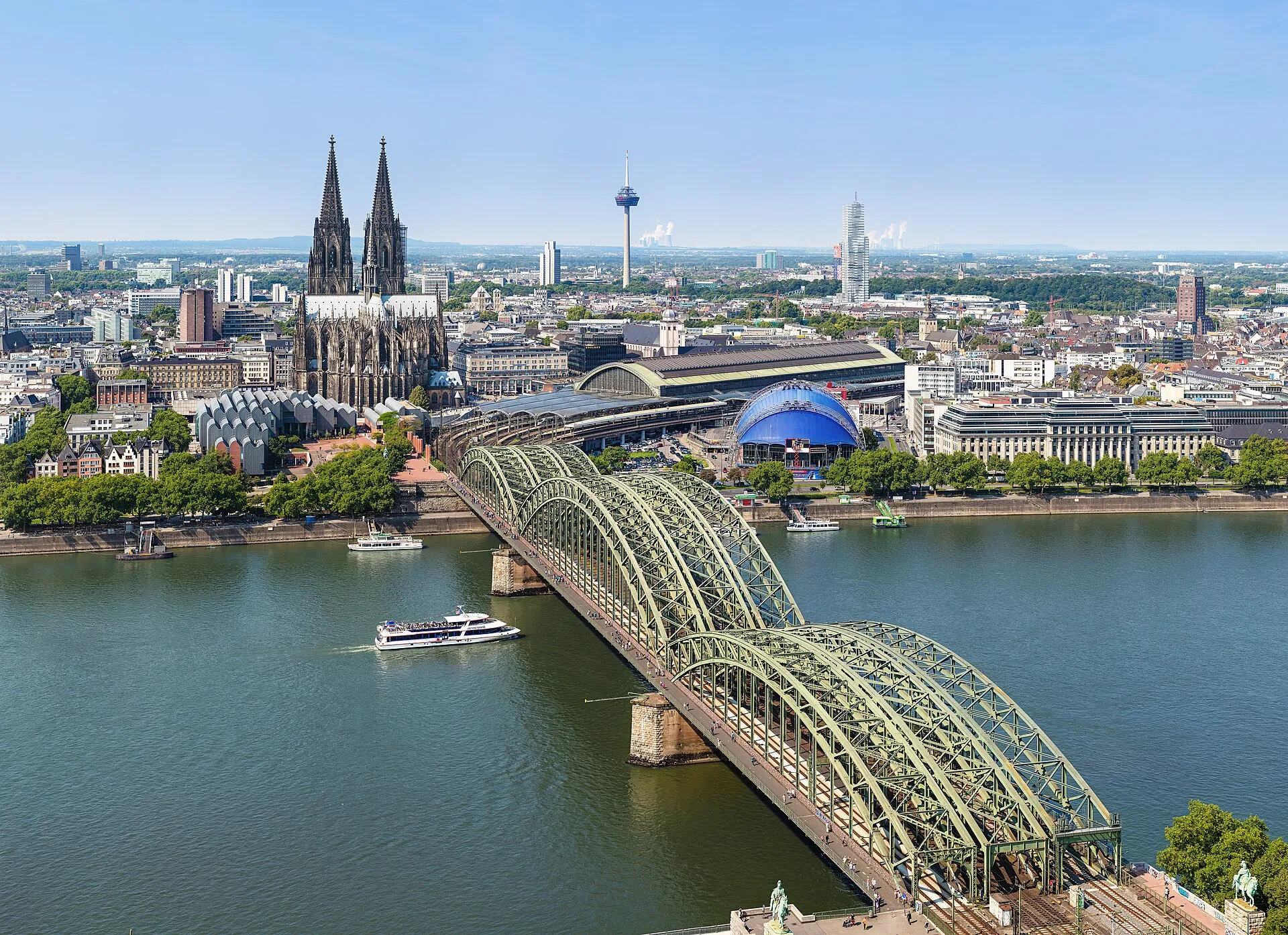
City portrait
Cologne – 2,000 years on the Rhine
Roman foundation, Gothic cathedral, lively quarters and Germany's biggest carnival – a portrait of the country's fourth-largest city in numbers, pictures and stories.
At a glance
Key figures
- Cathedral height
- 157 m
- world's tallest building 1880–1884
- Listed monuments
- 7.925
- across the city
- Migration background
- 43 %
- of the population
- Employment rate
- 60 %
- of the working-age population
- Green-space share
- 45 %
- parks, forest & water
- Carnival starts
- 11.11.
- at 11:11 a.m.
History
From Roman administrative seat to a city of a million: Cologne is one of Germany's oldest cities – founded in 38 BC and raised to a colonia as early as AD 50.
In 38 BC the Romans settled the Germanic Ubii on the Rhine – the Oppidum Ubiorum was born. In AD 50, at the instigation of Agrippina the Younger, who was born here, the settlement was granted city rights and the formal name Colonia Claudia Ara Agrippinensium. Over the centuries „Colonia" became „Köln".
As the seat of a powerful archbishopric from 795, the city grew in the Middle Ages into the largest city north of the Alps. In 1248 the foundation stone of the Gothic Cologne Cathedral was laid – yet it was not completed until 1880.
The Second World War destroyed almost the entire old town; the reconstruction still shapes the cityscape today. The Roman past reaches deep underground and is on display at the Römisch-Germanisches Museum in the heart of the city.
Cathedral & landmarks
Two spires, 157 metres tall, more than six centuries in the making: Cologne Cathedral is the city's emblem and a UNESCO World Heritage Site since 1996.
Officially the building is called Hohe Domkirche zu Köln. The Roman Catholic church is dedicated to the Apostle Peter and serves as the cathedral of the Archdiocese of Cologne as well as the metropolitan church of the ecclesiastical province of Cologne; its head is the cathedral provost. At a height of 157.22 metres, the cathedral is the fourth-tallest church in the world and, after Ulm Minster, the second-tallest sacred building in Germany.
The Gothic construction began in 1248 on the commission of Konrad I after a design by Master Gerhard and was completed only in 1880 on the commission of Friedrich Wilhelm IV following plans by Ernst Friedrich Zwirner. The church was conceived as the cathedral of the Cologne archbishops and as a reliquary for the remains of the Three Magi. On its completion in the 19th century it was regarded as a national symbol for Germany; after the Second World War the largely preserved structure amid the destroyed city was interpreted as a sign of the will to live.
The present cathedral has a long prehistory. Maternus, a confidant of Emperor Constantine I, is attested around 313 as the first bishop of Cologne. The early Christian community initially gathered in dwellings, one of them probably on the cathedral hill beneath today's choir, near the Rhine at the northern edge of the settlement. A baptismal basin excavated there, dating from the 5th century, is regarded as the oldest evidence of Christian worship in Cologne. In the 6th century the Merovingian kings erected a church 40 to 50 metres long at this site, which also served as a royal burial place.
In the Carolingian period the so-called Hildebold Cathedral was built, consecrated in 870, and at around 95 metres one of the largest churches of its era. As a basilica with two choirs, the eastern choir was dedicated to Mary and the western to Peter; with reference to Old St Peter's in Rome it was regarded as the Peter's church of the North. In 1164 Archbishop Rainald von Dassel brought the remains of the Three Magi from Milan to Cologne, for which the Shrine of the Three Kings was produced between 1190 and 1225. The city thereby became a place of pilgrimage.
With the start of construction of the Gothic cathedral in 1248, the Old Cathedral was to be dismantled; however, a fire during the demolition work largely destroyed it, though the shrine could be saved. Archbishop Konrad von Hochstaden laid the foundation stone on 15 August 1248. Master builder Gerhard designed a choir with a wreath of seven chapels, using trachyte from the Drachenfels as building material. In 1265 the chapel wreath was completed and used as a burial place; in 1277 Albertus Magnus consecrated the associated altar. The completion of the high choir was in the hands of master builder Arnold from 1271; around 1304 the choir was closed off to the west by a dividing wall that remained until 1863.
Carnival
On 11 November at 11:11 a.m. the „fifth season" begins. Its climax, the Rose Monday parade, is Germany's biggest street festival.
Cologne carnival is a way of life. The season officially opens on 11 November at 11:11 a.m.; street carnival begins on Weiberfastnacht (Women's Carnival) and peaks in the Rose Monday parade, watched by around a million people along a route several kilometres long.
The „Dreigestirn" of Prince, Farmer and Maiden leads the season, speeches ring out from the „Bütt", and everywhere the greeting is „Kölle Alaaf". In the neighbourhoods, smaller and more intimate Veedelszöch parades wind through the streets.
Those who want to dig deeper will find tradition, music and a language of its own woven into the carnival.
Rhine & geography
The Rhine splits Cologne into the left bank and right-bank Deutz – lifeline, viewing balcony and identity all at once.
Cologne's municipal area covers 405.01 square kilometres, of which 230.25 lie on the left bank of the Rhine and 174.87 on the right. The city sits in the Cologne Bay, a funnel-shaped river-valley landscape that the Rhine has shaped immediately after leaving the Rhenish Slate Mountains, between the slopes of the Bergisches Land and the Eifel. The highest point is the Monte Troodelöh in the Königsforst at 118.04 metres, the lowest lies at 37.5 metres above sea level in the Worringer Bruch. The tip of the northern cathedral tower serves as the topographical reference point.
After emerging from the slate mountains south of the city, the Rhine is referred to as the Lower Rhine. It reaches Cologne at Godorf and leaves it at Worringen; its gradient is about 0.2 per mille. The current water level can be read from the clock of the Cologne gauge, which shows 3.48 metres at normal water, corresponding to a depth of roughly 4.48 metres in the navigation channel.
The city was struck by floods several times. The most severe recorded event occurred in February 1784: after the long, cold winter of 1783/84 the Rhine had frozen over, and the onset of the snowmelt together with the breaking ice led to a record level of 13.55 metres. Drifting ice floes devastated the riverside buildings and all vessels, destroyed individual structures and claimed 65 lives. Mülheim am Rhein, situated on the right bank and today a district of Cologne, was completely destroyed.
In the 20th century the major floods of 1926, 1993 and 1995 reached levels of up to 10.69 metres. Since 2005 a flood-protection concept has been implemented that shields the city with fixed and mobile walls up to a gauge level of 11.90 metres.
Low water also occurred: on 20 September 2003 the gauge fell to 0.8 metres at 8 a.m., dropping below the value of 1947. This low was undercut again in October 2018, when only 0.67 metres were measured on 23 October. A gauge reading of 0 metres, however, means that the 150-metre-wide navigation channel in the middle of the river still holds one metre of water; inland shipping had to accept restrictions but was not halted as it was on the Elbe.
How much the water volumes differ according to the gauge level is shown by the figures: at 0.80 metres about 630 cubic metres per second flow through the city, at the normal level of 3.48 metres around 2,000, at 6.20 metres (flood mark I) 4,700, at 8.30 metres (flood mark II) 7,200, and during the January 1995 flood at 10.69 metres roughly 11,500 cubic metres per second. As of 2020, 63 per cent of the inhabitants live on the left bank; since the historic centre lies there, the right side is colloquially called the "Schäl Sick".
Quarters & boroughs
Cologne thinks in „Veedel": 9 boroughs, 86 quarters and countless neighbourhoods each with their own character – from Ehrenfeld to the Südstadt.
„Veedel" is the Cologne word for quarter – and more than that: it stands for neighbourhood, togetherness and local pride. Administratively, Cologne is divided into 9 boroughs and 86 quarters, but in everyday life it is the Veedel that counts.
Creative Ehrenfeld with its street art and clubs, the student-flavoured Südstadt, the chic Belgian Quarter or founder-era Nippes – every quarter has its own tone.
To understand Cologne, walk through the Veedel: across the markets, through the corner pubs and past the squares where life plays out.
Economy & media
Media, trade fairs, insurance: Cologne is a major business and media hub – with Koelnmesse as its global showcase.
Cologne is one of Germany's most important media cities: broadcasters, production companies and publishers are based here, alongside a strong insurance and trading sector.
Koelnmesse is one of the largest exhibition grounds in the world. Leading fairs such as the gamescom video-game show, the Anuga food fair and Art Cologne draw hundreds of thousands of trade visitors every year.
Cologne is also a central transport hub – with its main station right beside the cathedral, inland ports on the Rhine and Cologne Bonn Airport to the south.
Food & Kölsch
Top-fermented, pale, from the slender „Stange": Kölsch is both a beer and a language – served by the „Köbes" in the brewery tavern.
Kölsch is a pale, filtered, top-fermented full beer with an average original wort of 11.3 °P and an alcohol content of about 4.8 percent. It ferments at 15 to 20 °C, in many breweries even cooler at around 14 to 16 °C. It is brewed from barley malt, hops and water, with some producers adding a small share of wheat malt. The hops come mainly from the Lower Rhine, from the areas of Kerpen and Düren, as well as from the Hallertau and Tettnang on Lake Constance.
Cologne's brewing tradition goes back a long way: the Cologne brewing office has existed since 1250, and the brewers' cooperation formed in 1396 and signed the Verbundbrief, which secured Cologne a democratic constitution. Initially the beer was flavoured with gruit rather than hops; hops only prevailed in the 15th century. The brewers' guild ensured that not too many brewers settled, so their number remained nearly constant for almost 300 years. With the arrival of French revolutionary troops in 1794 came freedom of trade, and later industrialisation – for instance through the steam and cooling machine – led to the decline of the house breweries.
The first Kölsch in today's sense has been brewed since 1906 by the Sünner brewery, which first advertised the term in 1918. After the Second World War, in 1946 only the Dom and Sünner breweries remained; the first pure top-fermenting yeast was obtained by Hans Sion from Copenhagen. In 1963 the Cologne regional court ruled that Kölsch also indicates the region of origin, confirmed by the higher regional court in 1977. On 6 March 1986 the breweries signed the Kölsch Convention comprising 16 sections; the Federal Cartel Office recognised it on 29 January 1986. Since 25 November 1997 Kölsch has also been protected EU-wide as a regional specialty.
Kölsch is traditionally drunk from the Stange, a slim, cylindrical glass holding 0.2 litres, and served at 5 to 8 degrees. The waiter is called Köbes and carries the glasses in a Kranz holding up to 19 Stangen; the beer is tapped by the Zappes, sometimes still from wooden barrels. Occasionally there is the half Kölsch in the Stössje holding 0.1 litres, or the Pittermännchen, a 10-litre keg for self-tapping. In most brewhouses every guest receives a refill unasked until they place a beer mat on the glass.
Of originally around 100 brands, 26 still existed in 2008; some large breweries produce several varieties, partly as contract brewing. The breweries include Reissdorf, Früh, Päffgen, Gaffel and Sünner, among others. The predecessor Wieß is drunk unfiltered and naturally cloudy from glasses of 0.3 to 0.5 litres and is brewed again today, for example by Gaffel. Related beers are Altbier on the northern Lower Rhine, as well as Bönnsch in Bonn and the former Mölmsch in Mülheim.
A university city
With the long-established University of Cologne and numerous colleges, Cologne is one of Germany's largest places to study – over 90,000 students shape the city.
The University of Cologne was founded in 1388, making it one of the oldest universities in Central Europe; today it is one of Germany's largest. Alongside it, many specialised colleges shape the picture: TH Köln, the German Sport University, the University of Music and Dance and the Academy of Media Arts.
There are also private and church-run institutions such as the Rheinische Hochschule, CBS International Business School and the Catholic University of Applied Sciences.
Together, over 90,000 students make Cologne a young, lively university city – with a matching offer of culture, nightlife and creativity across the quarters.
Cologne in numbers
Demographics, land use and politics — from official open data.
Cologne first passed one million in the mid-1970s; after a boundary reform it briefly dropped below and has been above again since the 2010s.
Köln: age by sex (as of 31 Dec 2024).
Source: Regionalstatistik (Alter × Geschlecht) · tab. 12411-02-03-5
Source: Cologne neighbourhood monitoring
Köln compared
Köln compared with other major German cities. Tick areas — their values appear as coloured markers on the bars.
Tick areas — their values appear as coloured markers on the bars.
Structure
Source: Regionalstatistik
Land use (2015)
Economy & labour
Education & family (per 10,000 pop.)
Source: OpenStreetMap · facility map
Health & retail (per 10,000 pop.)
Source: OpenStreetMap · facility map
Sport & leisure (per 10,000 pop.)
Source: OpenStreetMap · facility map
Family & children
Mobility
Source: Federal Motor Transport Authority via Regionalstatistik
Municipal & tourism
Tick areas — their values appear as coloured markers on the bars.
Political mood (federal election 23.02.2025)
Source: Regionalstatistik · federal election (tab. 14111-01-04-4)
2,000 years in brief
- 38 v. Chr.The Romans found the Oppidum Ubiorum on the Rhine.
- 795Cologne becomes the seat of an archbishopric.
- 1248Foundation stone of the Gothic cathedral is laid.
© Thomas Wolf ( Der Wolf im Wald ) · CC BY-SA 3.0 - 1880The cathedral is completed after 632 years.
- 1945Severe destruction in the Second World War.
- 2005World Youth Day with over a million guests.
Did you know?
Cologne Cathedral was the tallest building in the world from 1880 to 1884.
„Eau de Cologne" made the city's name a global synonym for fragrance. The famous „4711" is named after its house number.
Almost half of the city – around 45 % – is green space.
Cologne has more than 7,900 listed monuments.
With over 90,000 students, Cologne is one of Germany's largest university cities.
Kölsch is both a beer and a language – both only „original" in Cologne.
Now explore the city
Sources & links
- offenedaten-koeln.de (retrieved 2026-06-30)
- offenedaten-koeln.de (retrieved 2026-06-30)
- Wikipedia (retrieved 2026-06-30)
- geoportal.stadt-koeln.de
- openstreetmap.org
How this page is made
This page draws on open sources — Wikipedia, Wikidata, official websites and the city’s open data. Every statement is checked against the sources linked here, and pages are refreshed regularly.
Spotted a mistake anyway? Tell us below — we read every submission.
Comments
- Loading comments…