Bahnhof Köln-Chorweiler
Shared underground station for S-Bahn and Stadtbahn in the heart of Chorweiler, whose Stadtbahn tracks were rebuilt several times to suit new vehicles
The station's history is closely tied to the Chorweiler large housing estate. Its lines were built before the first apartment blocks went up there.
At a Glance
- Type
- underground station for S-Bahn and Stadtbahn
- Location
- Liverpooler Platz, Chorweiler district and borough
- Opened
- 1973
- Named after
- Chorweiler
- Lines
- S11, plus S6 during peak hours; Stadtbahn line 15
- Special feature
- combined platform served by both S-Bahn and Stadtbahn
Because Chorweiler was first built on open fields, the S-Bahn and light-rail lines were laid before construction of the large housing estate even began. The light-rail tracks in the station were also altered several times: first raised with half a metre of extra ballast for trams, later lowered, and raised again in 2006.
Lines Before the Estate
S-Bahn and Stadtbahn infrastructure was laid out in open fields before construction of the estate itself had even begun. The S-Bahn line is a loop off the Cologne–Neuss railway, while the Stadtbahn line extends the tram route to Longerich. Openings followed the progress of residential development: tram line 9 reached Chorweiler first in 1973, and the S11 was added in 1975. On 22 May 1977 it was extended to Chorweiler Nord.
Station Layout
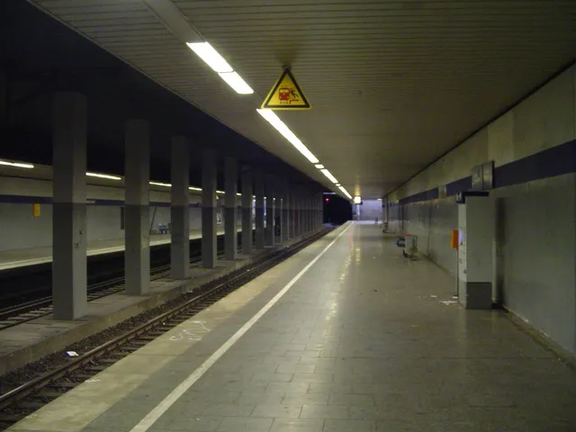
The station lies in a tunnel in the center of Chorweiler. Its 210-meter hall curves gently, is supported along its length by two rows of columns, and has an entrance at each end. To the west, a side platform serves the S-Bahn track for trains toward the city center. The considerably wider island platform has platform edges at the northbound S-Bahn track and at the Stadtbahn. To the east, a Stadtbahn track without a platform leads on to the former turning loop.
Stadtbahn Conversions
While the S-Bahn facilities remained largely unchanged, the Stadtbahn section was rebuilt several times. It was designed from the start for high-floor Stadtbahn vehicles. So that trams could run there at first, the tracks had been raised with an extra half meter of ballast. Line 9 used Duewag articulated cars; arriving trains ran through the turning loop, also located in the tunnel northeast of the platform, before stopping at the platform.
New Vehicles, New Operations
After the network reorganization of 1994, line 18 served Chorweiler with B-type cars, and the tracks were lowered to the originally planned height. These bidirectional vehicles made the turning loop unnecessary, so it was cut off at one end. Since then, arriving trains reach the station on the rear track, switch to the platform track in the middle of the station, and let passengers off there. After changing direction, they pull forward to the southern end of the platform and take on new passengers. Line 15 was added in 2003, initially also with B-type cars. In preparation for low-floor vehicles, the tracks were raised with ballast again during the 2006 summer holidays; since autumn 2006, line 15 has been a low-floor line.
Connections Today
Stadtbahn line 15 of the Kölner Verkehrsbetriebe terminates here and runs via Ebertplatz and Friesenplatz to Ubierring. In addition to the S11 of the S-Bahn Köln, the S6 of the S-Bahn Rhein-Ruhr also stops here during the morning and afternoon peak hours. Bus routes also serve the station. Chorweiler has a second connection to the S-Bahn network at Köln-Chorweiler Nord station.
Timeline
- 17. November 1973Tram line 9 begins serving Chorweiler
- 1. Juni 1975S-Bahn line S11 begins running to Chorweiler
- 22. Mai 1977S11 is extended to Chorweiler Nord
- 1994Network restructuring: line 18 serves Chorweiler, tracks lowered, turning loop cut
- 2003Network restructuring: line 15 reaches Chorweiler
- 2006Stadtbahn tracks re-ballasted; line 15 becomes a low-floor line
Gallery
Map
Blue dots: other places nearby — tap to explore.
You might also like — related or nearby
Comments
- Loading comments…
Sources & links
- Official website
- Official website (retrieved 2026-10-25)
- Wikidata (retrieved 2026-10-25)
- Wikipedia (retrieved 2026-10-25, rev 269313615)
Auto-generated, last verified: 2026-10-25
How this page is made
This page draws on open sources — Wikipedia, Wikidata, official websites and the city’s open data. Every statement is checked against the sources linked here, and pages are refreshed regularly.
Spotted a mistake anyway? Tell us below — we read every submission.