Haltepunkt Köln-Holweide
Von Fußballfans erkämpft: Der Halt entstand 1950 für Fans von Preußen Dellbrück und hieß im Volksmund „Willy-Röhrig-Gedächtnisbahnhof“.
The line the station sits on is no longer fully operated today. Even so, it remains the gateway to the S-Bahn network for the surrounding residential area.
At a Glance
- Type
- S-Bahn halt (stop)
- Location
- Höhenhaus district, Mülheim borough, right on the border with Holweide
- Address
- Pfarrer-Maybaum-Weg 60, 51067 Cologne
- Line
- Köln-Mülheim–Lindlar railway
- Train services since
- 1950
- Connections
- S-Bahn line S 11, Kölner Verkehrs-Betriebe bus line 157
The halt came into being in 1950 thanks to football fans of SC Preußen Dellbrück: club chairman and building contractor Willy Röhrig had it built in very short order, which is why locals later nicknamed it the "Willy-Röhrig-Gedächtnisbahnhof" (Willy Röhrig Memorial Station).
Born from a Football Fans' Initiative
In the early 1950s, SC Preußen Dellbrück was competing for the German championship. Many of its supporters came from Holweide and wanted to board the special trains to away games there. So they applied for a stop on the line, which the Bergisch-Märkische Eisenbahn-Gesellschaft had already opened in 1868. They found support in the club's then chairman, Willy Röhrig, who lobbied the Deutsche Bundesbahn on behalf of the project.
A Ramp as a Condition
The Bundesbahn agreed but demanded a temporary ramp for boarding and alighting. For Röhrig this was no obstacle: he was a building contractor and had the stop built in no time. The Bundesbahn approved it, and trains stopped there from 1950. Because they also kept stopping on schedule after the football matches, the stop became permanent. It was later nicknamed the "Willy-Röhrig-Gedächtnisbahnhof" (Willy Röhrig Memorial Station) by locals.
From Fan Stop to S-Bahn
As commuter traffic from Bergisch Gladbach to Cologne grew, the timetable became denser. The Bundesbahn therefore opted for S-Bahn service. From 1972, the line was electrified and upgraded to S-Bahn standard. In 1975, an S-Bahn line from Bergisch Gladbach to Köln-Chorweiler began operating.
Between Holweide and Höhenhaus
According to Wikipedia, the station lies on the northern edge of Holweide, directly on the border with Höhenhaus. According to OpenStreetMap map data, the site belongs to the Höhenhaus district. Despite its name, the station thus serves both districts and connects them quickly by S-Bahn to Cologne Central Station.
Platforms and Access
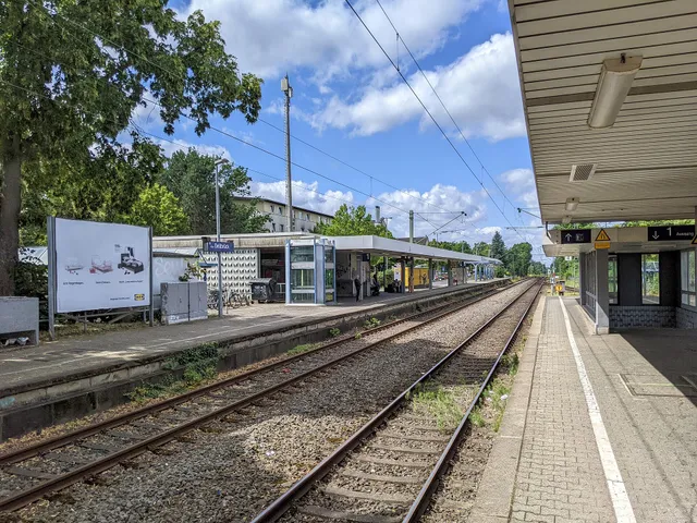
The station has two side platforms with a height of 76 centimetres. Freight traffic towards Bergisch Gladbach prevents raising them to 96 centimetres, so the platforms remain at the lower height. Each side has step-free access, and both ends have stairs with underpasses for pedestrians and cyclists. The bus stop is on the east side, and bicycle parking is available. The station is unstaffed, and no on-site assistance is available.
Timeline
- 1868Opening of the Köln-Mülheim–Bensberg railway line by the Bergisch-Märkische Eisenbahn-Gesellschaft
- 1950Deutsche Bundesbahn trains begin stopping at the Holweide halt
- 1972Start of line electrification and upgrade to S-Bahn standard
- 1975Launch of an S-Bahn line from Bergisch Gladbach to Köln-Chorweiler
Map
Blue dots: other places nearby — tap to explore.
You might also like — related or nearby
Comments
- Loading comments…
Sources & links
- Official website
- Official website (retrieved 2026-10-28)
- Wikidata (retrieved 2026-10-28)
- Wikipedia (retrieved 2026-10-28, rev 261382478)
Auto-generated, last verified: 2026-10-28
How this page is made
This page draws on open sources — Wikipedia, Wikidata, official websites and the city’s open data. Every statement is checked against the sources linked here, and pages are refreshed regularly.
Spotted a mistake anyway? Tell us below — we read every submission.