Rathenauplatz
Cologne's leafy Südstadt park with a plane-tree avenue, a popular beer garden, and a name that mirrors Germany's turbulent 20th century.
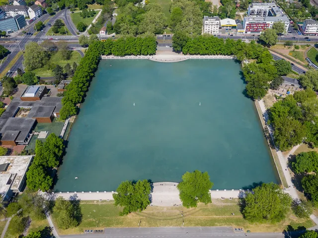
Rathenauplatz is a 2.77-hectare public park in Cologne's Südstadt (city district Innenstadt). Enclosed by Roonstraße, Zülpicher Straße, Dasselstraße and Lindenstraße, it forms the green heart of the surrounding Rathenauviertel neighbourhood.
At a Glance
- Type
- public park / city square
- Location
- Südstadt (Innenstadt district), between Roon-, Zülpicher-, Dassel- and Lindenstraße
- Size
- approx. 27,700 m² (2.77 ha)
- Planting
- plane-tree avenue around the perimeter, over 200 trees, 260 m of flowering shrubs (mainly lilac)
- Facilities
- central lawn, two children's playgrounds, benches
- Highlight
- beer garden at the centre of the park
- Surroundings
- opposite the synagogue on Roonstraße
Under the Nazis, the square was renamed 'Horst-Wessel-Platz' – directly opposite the imposing synagogue on Roonstraße, which thus literally faced their so-called 'martyr's' namesake square.
Origins
The site originally lay outside the city walls and was used as farmland. Following the demolition of the medieval fortifications from 1881 onwards, Cologne's Neustadt was developed to plans by city architect Josef Stübben. A marshy hollow that proved too low-lying to build on was left behind and eventually converted into green space.
From Festival Ground to Park
Stübben had originally envisioned a festival ground here, complete with a royal monument, flagpoles and a fountain. The planned Volksgarten was eventually built elsewhere. Instead, city parks director Adolf Kowallek proposed a ring of plane trees around a central shrub-bordered lawn — and this was the plan that was realised. Paths connect the square to the surrounding streets, with two playgrounds and numerous benches added throughout.
A Name That Reflects History
A proposal to name the square after King Frederick William IV of Prussia failed in council in 1887, and the name Königsplatz was adopted instead. Following the assassination of Walther Rathenau in June 1922, the square was renamed Rathenauplatz in 1923, on the initiative of the Social Democratic group. The Nazis replaced the name with Horst-Wessel-Platz in 1933; since the end of the Nazi era, the square has been known once again as Rathenauplatz.
The Neighbourhood Today
The residential area between the ring roads and the university is officially called Rathenauviertel, but is also widely known as the Zülpicher Viertel, Univiertel or Kwartier Latäng. Taking its cue from Paris's Quartier Latin, the area is home to small independent theatres, lively bars and restaurants with diverse cuisines. The Bürgergemeinschaft Rathenauplatz e.V., founded in 1977, has run the beer garden at the centre of the square since 2000.
Timeline
- 1881Demolition of the medieval city wall begins; urban expansion following Josef Stübben's plans
- 1887Named 'Königsplatz' after vote on Friedrich Wilhelm IV. naming fails in city council
- 1890Roonstraße and surroundings still sparsely developed; area still under construction
- 1897–1899School building on Lochnerstraße built by city architect Friedrich Carl Heimann
- 1922Assassination of Walther Rathenau in June 1922
- 1923Renamed 'Rathenauplatz' at the request of the Social Democratic council faction
- 1933Nazis rename the square 'Horst-Wessel-Platz' after seizing power
- 1977Founding of the citizens' association Bürgergemeinschaft Rathenauplatz e.V.
Map
Blue dots: other places nearby — tap to explore.
Address
Rathenaupl.
50674 Köln
You might also like — related or nearby
Comments
- Loading comments…
Sources & links
Auto-generated, last verified: 2026-06-27
How this page is made
This page draws on open sources — Wikipedia, Wikidata, official websites and the city’s open data. Every statement is checked against the sources linked here, and pages are refreshed regularly.
Spotted a mistake anyway? Tell us below — we read every submission.